
City Buzz is the semi-annual newsletter of the Minneapolis-St. Paul Metropolitan Area Urban Long-Term Ecological Research Program (MSP LTER), produced to inform interested partners and community members of our work.
FROM THE DIRECTOR
Happy Fall! A number of us have just returned from attending the LTER All-Scientists Meeting in Asilomar, CA. This gathering happens every three years and brings together students, postdocs, staff, faculty and other researchers from across the 28 sites that make up the national NSF-funded network of LTER sites. Sites range from open-ocean to coastal, desert to grassland to forest, arctic to Antarctic. MSP is one of only three urban sites in the network. For many of us, it was our first time attending a conference in person in a long while, and it was a great opportunity to connect with old friends, build new relationships, and explore possibilities for collaboration across sites, which all share a focus on studying human-environment interactions over the long term. MSP attendees led workshops on the effects of urbanization on evolution, knowledge co-production, and the role of legacies of past inputs of phosphorus in contributing to present-day water quality challenges. They presented work on the present-day consequences of past discriminatory housing policies for urban nature and shared our approaches to building relationships with community partners. As someone who has attended these meetings for decades now, it was exciting to hear all the discussion of knowledge co-production, environmental justice, and integration of traditional ecological knowledge and western science. We are all learning and growing together.
-Sarah Hobbie, Director and Lead Principal Investigator
MSP LTER STORIES
Connecting students to urban science: Developing curriculum for the urban Long Term Ecological Research Program
The Bell Museum is the lead outreach and education partner for the MSP LTER, focusing on creating urban ecology field trip experiences for middle school students as well as supporting student learning and exploration in their own schoolyards. This summer, the Bell Museum in collaboration with the University of St. Thomas hosted Lauren Reuss, a middle school life science teacher from Benilde-St. Margaret. This summer, Lauren worked with Bell educators and MSP LTER researchers to develop new urban ecology lesson plans and resources that could be used on-site at the Bell and in classrooms throughout the Twin Cities Metro.

Lauren Reuss in the field
Reuss has been taking a hands-on approach to curriculum development. Periodically, she went into the field to work with researchers on the project. Since the MSP LTER takes an interdisciplinary approach to studying urban ecology, Reuss shadowed a variety of different research teams in the field—including the lakes and stream team, the urban contaminants team (who study squirrels and butterflies), and the pollinators team. She used these experiences to better understand what the researchers were doing (What kinds of questions they were asking? What tools and methods were they using? What kind of data they were collecting?) and to communicate that information back to the students.
Ultimately, Reuss decided to focus on the work of the group studying the differences between urban and rural squirrels, particularly what effects the urban environment might have on squirrel behavior. Squirrels are common in the urban environment and are easily accessible for students to study. After shadowing Charlotte Devitz, a graduate student in Professor Emilie Snell-Rood’s Lab, conducting field research with squirrels on the lawns of the St. Paul campus in July, Reuss was inspired to create a series of lessons focused on squirrel behavior and adaptation to the urban environment. In one lesson, students will study squirrel “boldness.” Students will collect real data on squirrels by conducting “flight initiation distance tests” at home, in schoolyards or nearby parks. These tests measure how close you can get to a squirrel before it runs away. Reuss hopes that by conducting this research, students will see clear patterns and will get excited about collecting and analyzing data. She plans to pilot these squirrel lessons—including one with her students on a field trip to the Bell—later this fall.

Charlotte Devitz handling a squirrel in the field
This work and the MSP LTER has a special place in Reuss’s heart. An environmental science major in college, she shared that it was nice to get back in the field doing science; sometimes teachers get rooted in the day to day—and it’s nice to remember what the big driving scientific questions are. Additionally, she particularly loves the MSP LTER because it can help us appreciate and notice what’s actually happening around us, in our urban environments.
Lauren summed it up well: “It’s important to learn about the environment where students actually live, instead of viewing nature as just ‘wild’ places.”
- Emily Dzieweczynski, Bell Museum. This story was adapted from a post that first appeared on the Bell Blog on 08/11/2022.
Nature, race and real estate in Minneapolis-St. Paul
Amid growing awareness of environmental injustice, our historical research shows that unequal access to urban green space was no accident. The relationship between wealth, whiteness, and greenness was baked into the landscape as it was first developed.
In 1913, Minnesota state congressman Thomas Frankson purchased 120 acres for residential development along the western edge of St. Paul’s flagship Como Park. Newspaper ads for Frankson's Como Park Addition emphasized proximity to the park and featured photos of the lake and gardens. A creative salesman, Frankson also brought a pair of bison–a species on the verge of extinction–to graze on empty lots and generate excitement (he eventually donated them to the nearby Como Zoo). In the 1920s, Frankson sold 30 acres to complete a municipal golf course at Como Park, another attraction that would raise the value of the surrounding properties.
Aside from these amenities, the newspaper ads touted restrictions embedded in each deed. Frankson inserted covenants that barred people of color from owning or occupying the parcels, one of the first developers to use racially restrictive covenants in the city. By 1916, Frankson had also placed ads in the Swedish-language newspaper Svenska Folkets Tidning, which emphasized many of the same points, illustrating the value ascribed to whiteness in the social hierarchy over primary language spoken or national origin. And this whiteness was linked to economic value, for example, in this advertisement in the local newspaper (Figure 1).
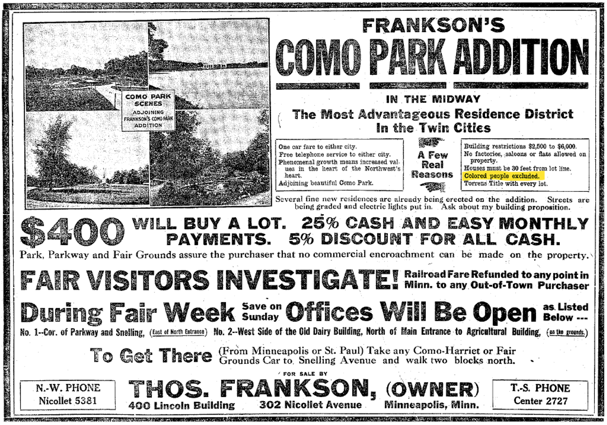
Figure 1. An advertisement for Frankson’s Como Park Addition, from the Minneapolis Tribune, August 30, 1913, p. 10
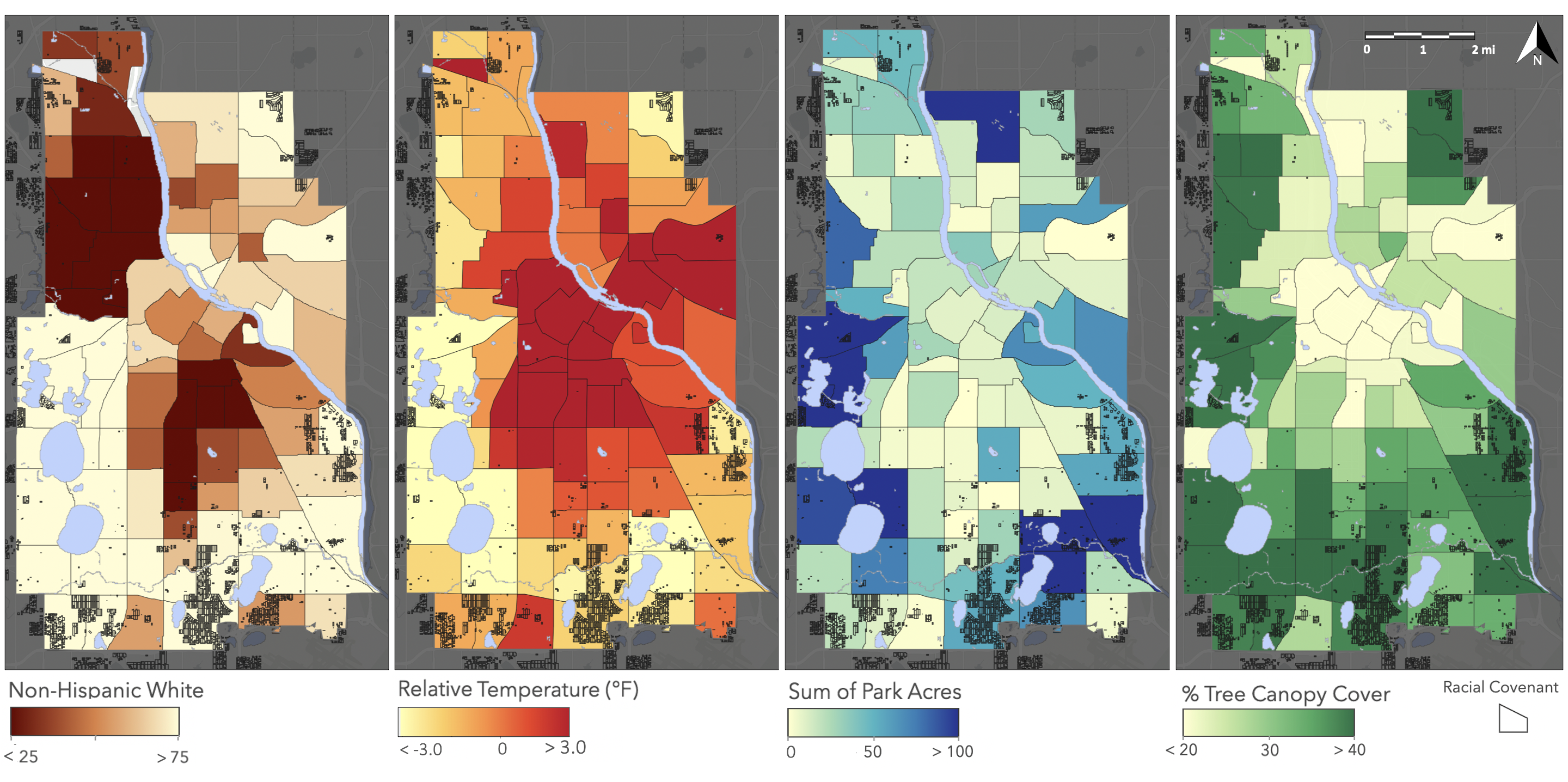
Figure 2. Environmental legacy of racial covenants. Variables averaged within neighborhood boundaries. Maps are overlaid with the map of racial covenants, with parcel boundaries drawn in black. Shaded areas are beyond Minneapolis city limits. Covenant data source: Mapping Prejudice. a. Non-Hispanic white share of the population. Lighter colors indicate a higher share of the population identifying as non-Hispanic white on the census. Data source: U.S. Census, 2020. b. Average temperature, relative to the citywide mean temperature, in ºF. Darker colors indicate hotter temperatures. Data source: LANDSAT 8 satellite data. c. Total park area, calculated as the sum of all park acreage located within the boundaries of each neighborhood. Data source: City of Minneapolis. d. Tree canopy cover, calculated as the share of neighborhood land surface covered by tree canopy. Data source: Knight et al., 2017.
-Rebecca Walker, graduate student, and Hannah Ramer, postdoc, Hubert H. Humphrey School for Public Affairs at the University of Minnesota
ABOUT US
Who: 30+ researchers, educators, and community organizers from the University of Minnesota, University of St. Thomas, US Forest Service, The Nature Conservancy, and Water Bar
What: Long term research on ecological relationships between human and nature in cities
How: A six-year, $7.1 million, renewable grant from the Nation-al Science Foundation to establish a new site as part of the US LTER Network. The grant began in March 2021 and primarily supports postdocs, students, and staff in research, education, and engagement efforts.
Where: Seven-County Twin Cities Metropolitan Area in the State of Minnesota or Mni Sota Makoce in Dakota. What we now call the Twin Cities Metropolitan Area are the traditional, historical, and contemporary lands of the Dakota People.
To learn more, visit our website at mspurbanlter.umn.edu, or contact Sarah Hobbie, Director, [email protected] or Susan Barrott, Program Coordinator, at [email protected].