City Buzz is the semi-annual newsletter of the Minneapolis-St. Paul Metropolitan Area Urban Long-Term Ecological Research Program (MSP LTER), produced to inform interested partners and community members of our work.
FROM THE DIRECTOR
I’m excited to celebrate our one-year project anniversary by introducing our first City Buzz, the newsletter of the new MSP LTER. We hope to use this semi-annual newsletter to invite you to Upcoming Events, tell you about some of our ongoing activities in our MSP Stories, highlight some of the data that we’re collecting or synthesizing in The Data Stream, as well as other exciting news. It’s hard to believe, but in mid-March we celebrated our one-year anniversary of receiving funding for the new MSP LTER. We’ve been busy this year turning our ideas into action: establishing new partnerships, developing research methods, locating research sites, synthesizing existing data, and collecting new data from lawns, lakes, parks, and cities. We’ve also been listening and learning, so that we can advance our ultimate goal of improving environmental outcomes for all urban residents with humility and respect for the wealth and diversity of knowledge and perspectives that exist here in the Twin Cities.
-Sarah Hobbie, Director and Lead Principal Investigator
UPCOMING EVENTS
Annual All-Hands Meeting, June 2
On the morning of June 2, we invite interested community members to join us for presentations of the different MSP projects, followed by opportunities for discussion and interaction among MSP participants, community partners, and members of the public. Register here. We are currently planning to hold this meeting in person at the Institute on the Environment on the University of Minnesota’s St. Paul campus.
MSP STORIES
Joining Efforts to Restore a Sacred Gathering Place
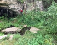
Many of the unique land formations in what is now called the Twin Cities Metropolitan Area are sacred to indigenous peoples. This is true of a special place along a bend in the Mississippi River in downtown St Paul, where a series of springs flow from caves tucked into the sandstone bluffs. This place, named Wakáŋ Tipi by the Dakota, has been a sacred gathering site for thousands of years, with burial mounds at the top of the bluff. But now, this place is highly affected by urban development. Nearby streams that used to flow into the river move through underground pipes, I-94 winds its way along one edge, with railroad tracks buffering the other, and scars of past industry and railyards checker the space, while the caves bear damage from vandalism and dynamite.
The “toxins team” of the LTER first came across Wakáŋ Tipi, also known as Bruce Vento Nature Sanctuary, while staring at maps and spreadsheets. We were looking for places where we could study how urban toxins move through ecosystems, why some species are more tolerant of such toxins, and how ecological restoration might help us deal with these pollutants. As we aligned the Department of Health’s map of childhood blood lead levels with maps of parks and gardens, we noticed that Wakáŋ Tipi falls in an area with some of the highest childhood lead levels in the state. The site was on our radar, and then a winding chain of email forwards put us in touch with the staff of the native-led Lower Phalen Creek Project (LPCP).
It was a warm day in July when we first met up with the LPCP team – Sam, Keeli and Mishaila – at Wakáŋ Tipi. We criss-crossed the prairie restoration in the site, noting how so many of the plants valuable to pollinators are also important medicinal plants to Dakota people. Cold water trickled out of the gated-off caves, and we gazed up at an amphitheater of sandstone cliffs, tarnished in places by graffiti. As we wandered through the site, we discussed the ways that soil and plant sampling for metals might give a better idea of patterns of remnant and current contamination, converging on questions and approaches that worked for all of us.
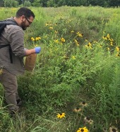
A few weeks later, with the permission of LPCP, the LTER team came back with soil corers and paper bags to take samples of soil, and leaves of five species of prairie plants as a first exploration of where metal contamination might be elevated. It was even warmer that day and we had to wear gloves to keep sweat from contaminating the samples, since we were also measuring sodium levels. We dried the samples and sent them off to the analytical lab at the University of Minnesota campus to measure metals. When the data came back weeks later, we all joined together on a Zoom call to do some data analyses. We compared the plants to the same species collected along roadsides to get an idea of what we might expect for a semi-polluted site. It was easy to see that levels of some metals were elevated in prairie plants at Wakáŋ Tipi, like lead and arsenic, but others, like nickel, were not. The soil data were quite patchy, with a handful of subsites showing elevated arsenic, and one area containing somewhat concerning levels of lead. The analysis gave some ideas of what metals might be of concern, but it wasn’t all bad news, as it also highlighted how the plant contamination was likely lower than levels that would kill pollinators at the site.
Some of the soil and plant analyses raised questions about how water might be moving through the site, redistributing toxins from one place to another. It doesn’t take much to get scientists intrigued, and discussing some of the patterns with LTER members who work on aquatic systems has led to a growing LTER-LPCP partnership. We found ourselves touring the site again recently, this time in subzero temperatures, using water probes to take initial measurements of spring-fed water moving through Wakan Tipi through a stream and series of ponds, before entering a final pipe out to the Mississippi River. This spring, a class from St. Thomas University is incorporating many of the water research questions into their own class project, further expanding our growing partnership.
Most rewarding about the research has been how many of the more specific research questions have arisen organically out of collaborative, iterative discussions with LPCP staff. Our findings are informing not only our broader research questions, but also concerns of LPCP and surrounding communities about the overall ecological health of the site. In the longer run, we hope that specific restoration techniques or soil amendments can help to reduce the negative effects of these contaminants. And in doing so, continue to heal this sacred site that has been so tarnished by decades of industrial development, so that it can be a gathering place that also heals its community. While we came into this site through a map of contamination, our connection to this site has grown as we have learned Dakota stories and gotten to know some of the people that value this place so deeply.
-Emilie Snell-Rood, Professor in the Ecology, Evolution and Behavior Department at the University of Minnesota
Shades of green: urban tree biodiversity and its relationship to climate and social vulnerability
Trees in cities have been making a name for themselves as of late. Major news outlets have been highlighting the role of trees in creating more livable urban spaces. For example, trees can regulate water runoff, moderate extreme temperatures, and provide recreational and mental health benefits to residents. Here in Minnesota and across the globe, efforts abound to plant more trees in order to paint our cities green and increase urban sustainability. What has gotten less press (and less research) is a more nuanced picture of the shades of green that line our city streets and populate our urban parks and yards – that is, the diversity of trees that make up our urban forests.
Beyond total tree canopy cover, the kinds of trees that make up the urban forest (which species they are, what characteristics they have) can be important for a variety of environmental and social reasons. For example, many of us are familiar with the recent decline of ash trees across the region due to emergence of the emerald ash borer (EAB), whose larvae feed on and kill ash trees. Diversifying the tree canopy not only reduces the total number of ash trees susceptible to EAB but also reduces the ability of EAB to spread. Tree diversity can also be important for supporting vibrant and diverse urban human populations, as different tree species may provide culturally important foods, fibers, and spiritual connections. Understanding patterns of urban tree biodiversity – the shades of green that make up our urban forests – can help us plan and manage for more culturally-inclusive and resilient cities as we face ongoing social and environmental changes. Such understanding can also help us discover whether the benefits associated with having more diverse urban forests are being experienced more by some communities than others.
The urban forest research team with the MSP LTER is documenting and exploring patterns of tree biodiversity across the metro area by asking questions such as, “where do we see patches of remarkably high or low tree diversity?”, “do these patches relate to patterns of environmental vulnerability, such as rising temperatures and pest and pathogen outbreaks, and social vulnerability, such as rates of poverty or homeownership?” As a first step to answering these questions, we have brought together data from 40 cities, park systems, and local organizations across the MSP who have generously shared data from on-the-ground inventories of their urban forests.
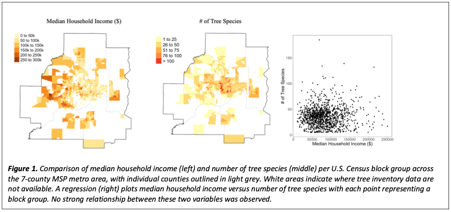
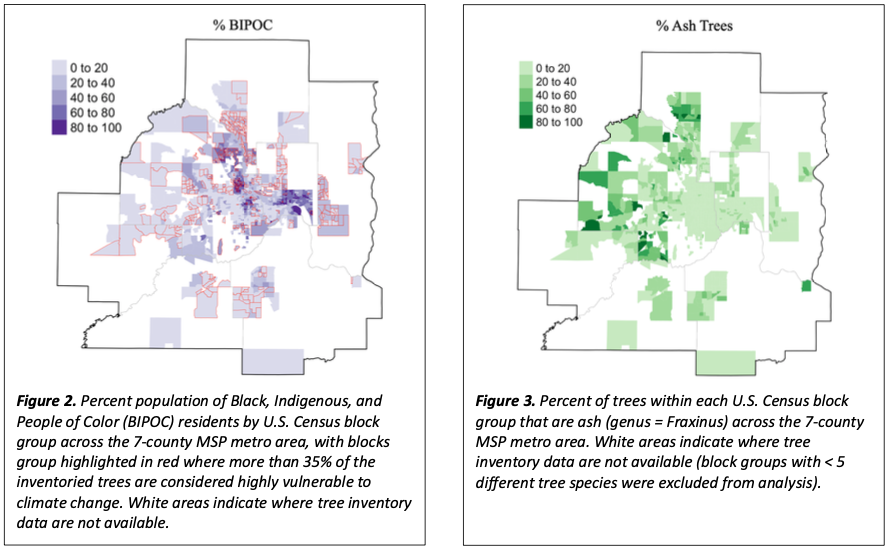
Perhaps surprisingly, preliminary results suggest there is not a strong relationship between social variables, such as median household income, and tree biodiversity across the metro area (Figure 1). In the urban center, some U.S. Census block groups boast more than 100 different tree species, while it is more common to find block groups with fewer than 50 different species. There is some spatial overlap of social and climate vulnerability, particularly in parts of Hennepin County, but these variables are not consistently related across the metro area (Figure 2). The proportion of ash trees in a given area is of concern to managers and residents, due to the susceptibility of ash to EAB, and suburban and ex-urban regions of the metro area appear to have greater proportion of ash compared to the urban core (Figure 3).
The project to date has focused on discerning patterns of urban forest diversity using tree inventory data. These kinds of data have their limitations, since they mostly come from public lands, especially trees along roadways. Furthermore, not all cities have the capacity or resources to produce such inventories. Ultimately, the LTER hopes to be able to use remote sensing data from aircraft or satellites to be able to measure the biodiversity of the urban forest from space, a lofty goal that we hope to someday achieve.
-Adrienne Keller, Postdoc in the Ecology, Evolution and Behavior Department at the University of Minnesota
The DATA STREAM
What is the deal with the weather…data?
Weather you were looking or not, two popular sources for open weather data were acquired by big tech companies. Dark Sky went to Apple, and Weather Underground went to IBM a few years ago. The Dark Sky API, popular among researchers looking for historical weather data, was discontinued in late 2021. When I went to use an R script last year that called the Weather Underground API, the R package no longer had access, as their API was retired in late 2018. Scripts that depended on these tools will be degradated, limiting research reproducibility, an important quality of any long-term research project. At the MSP LTER, we are prioritizing an interface to open-access climate station data and coalescing our own station and sensor reports across the Twin Cities Metro Area, along with resources from agencies and nonprofits such as NOAA and CoCoRaHS (Community Collaborative Rain, Hail and Snow Network). So far, the web app under our data catalog provides links to these external resources and their TCMA station locations, but we plan to include our own data and additional crowd-sourced meteorological and hydrological data in the near future!
-Mary Marek-Spartz, Information Manager for the MSP LTER
ABOUT US
MSP is a new urban LTER program in the Twin Cities studying how urban stressors – climate change, pollutants, invasive species, habitat fragmentation – affect the ecological structure and functioning of urban nature, including pollinators, forests, watersheds, and lakes and streams. We also study how diverse residents interact with and experience the benefits and burdens of urban nature. Ultimately, we aim to better understand urban nature and related policies and practices, to improve environmental outcomes for all residents.
Who: 30+ researchers, educators, and community organizers from the University of Minnesota, University of St. Thomas, US Forest Service, The Nature Conservancy, and Water Bar
What: Long term research on ecological relationships between human and nature in cities
How: A six-year, $7.1 million, renewable grant from the Nation-al Science Foundation to establish a new site as part of the US LTER Network. The grant began in March 2021 and primarily supports postdocs, students, and staff in research, education, and engagement efforts.
Where: Seven-County Twin Cities Metropolitan Area in the State of Minnesota or Mni Sota Makoce in Dakota. What we now call the Twin Cities Metropolitan Area are the traditional, historical, and contemporary lands of the Dakota People.
To learn more, visit our website at mspurbanlter.umn.edu, or contact Sarah Hobbie, Director, [email protected] or Susan Barrott, Program Coordinator, at [email protected].